
April 27, 2021. By Kolemann Lutz
Russian scientists compared GPR data with soil color layers and soil properties to accurately determine the underground soil colors on Earth with 80 percent accuracy without digging or excavating.
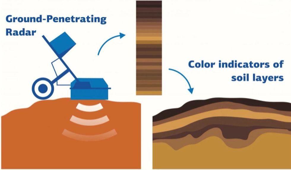
Traditionally, soil properties and changes at different depths were determined by extracting soil core samples. Scientists recently determined that the same data can be obtained much more easily, using ground-penetrating radar (GPR), which made tremendous technological advances in the 60s and 70s. The color of soils varies accordingly with mineral content, density, salinity, humidity, and humus content, which makes it possible to observe color variations in the soil core samples. More energy and heavier equipment are typically required to excavate longer, deeper samples.
Ground-penetrating radar (GPR) profiling is currently rapidly developing on Earth and works by wirelessly emitting microwave radio pulses into the ground and recording the reflected signals of subsurface objects. Different wavelengths of reflected microwaves correspond to different soil colors, which often is an indicator of soil property changes, diagnostics, and classification in addition to other methodologies such as remote sensing and proximal sensing. GPR is also used to create subsurface maps of soil water content, metals, utility lines and pipes, air pockets, bedrock, geological features, and changes in ground strata.
Synthetic aperture radar (SAR) satellites also hold the potential to collect sub 25-centimeter high resolution imagery over candidate surface regolith and soils. Although subsurface colors and soil properties are not accessible from space-based optical and radar instrumentation.
Since plants soil will be grown indoors in greenhouses on Mars, other instruments and sensors will be utilised to collect soil parameter data for crops and biomass production. During the past climatic eras, deeply buried ice deposits formed and built up over time. Sufficiently isolated from the atmosphere, the thick subsurface layers composed of pure water ice are detectable by ground penetrating radar because of their lower dielectric constant and lower attenuation compared to soil.
Scientists from RUDN University analysed the relationship between ground-penetrating radar (GPR) data with soil color layers at seven sites in Russia's Kamennaya Steppe nature preserve. 30 core samples from each site, down to depths of 10 cm (3.9 in) to 3 meters (9.8 ft), were extracted. Colors at different depths in soil samples were compared with GPR scans' red, green and blue wavelength data. In analysing EM reflections on the radargrams, a RGB model was constructed by matching different chromaticity wavelength readings to different soil layers and colors. Mathematical analysis was conducted by taking the Fourier transform or integral of the amplitude of reflected pulse in subsurface soils. A series of polynomial models highlighted the relationships of probe pulses and some diagnostic indicators of soils such as clay fraction, soil density, moisture, and humus.
“It was subsequently found that by applying that model to GPR data alone, it was possible to determine the underground soil colors at a given site with 80 percent accuracy. That figure should improve as the technology is developed further”, mentioned by lead author, A. Ya. Voronin from the Dokuchaev Soil Science Institute. The system initially has to be calibrated using a core sample from the local region before GPR scans at multiple sites without the need for additional samples.
Inspired from a lack of efficient root system analysis and phenotyping on Earth, researchers at Texas A&M conducted a separate study in 2017, which was the first to demonstrate the high potential of GPR to be effectively used in detecting the fine roots of plants to determine crop selection and breeding for the local environment.
Understanding the local soil health and quality and corresping color layers are important for photosynthesis, cyanobacteria, root and mycelia growth, water flow in .37Gs, water absorption and drainage, and more. Several studies have also demonstrated that GPR can be used to map plant and tree roots, quantify spatial distribution, estimate root diameter, bulking rates, and below ground biomass. To better understand seasonal variation in root detection over months and years with the presence of liquid water, several 20 m transects were established and 8 mm aluminum rods were horizontally inserted into undisturbed soil to predict below ground biomass and estimate root bulking rates. The relatively high iron content of Martian regolith (14% iron by weight), clay minerals, clathrate hydrates water ice, and EM scattering from heterogeneities isotopes are believed to control and impose challenges for using GPR at greater subsurface depths. Several ground penetrating radar systems have been and will be launched to and operated on Mars.
The Radar Imager for Mars' Subsurface Experiment, known as RIMFAX, was recently launched aboard the Mars Perseverance Rover. RIMFAX antenna holds the potential to address many of these issues by observing the depth of the porous regolith and the transition to bedrock, the distribution of clasts of bedrock fragments, and the presence of decomposed organic matter. By probing the ground under Perseverance, the 3 kg 10-watt RIMFAX can collect data with 15 to 30cm vertical resolution and reach penetration depths greater than 30feet (10m), depending on materials.
In summary, the Russian scientists demonstrated GPR can determine underground soil colors on Earth with 80 percent accuracy without digging, which holds the potential to help improve the GPR method, scans and analysis on the Martian surface to support organic life.
Voronin, A.Y., Savin, I.Y. Correlation between Color of Subsurface Soil Horizons and Ground-Penetrating Radar Data. Eurasian Soil Sc. 53, 1119–1131. September 2020. https://doi.org/10.1134/S1064229320080165

Comments